Getting started with tasking
See all articlesGetting started: Order a New Satellite Imagery
Ordering Satellite Imagery
This guide walks you through tasking/ordering satellite imagery, from selecting your area of interest to completing your purchase.
What's Covered:
- Account setup
- Create a new order
- Place order
- Completing Your Purchase
Step 1: Account setup
Sign up to Aurora to create your org. Once you have created an org, add members and projects to get started.
Step 2: Complete your KYC/KYB (for compliance)
Navigate to: Order Desk → Order New Image
You will be required to complete the KYC/KYB, for more information refer to this article.
Step 3: Creating your Order
- Choose your Area of Interest (AOI) by drawing on the map or uploading
- Set capture time window
Step 4: Add to cart
Before adding to cart:
- Select your required parameters
- Click "Check feasibility" to verify satellite availability
- Once feasible, click "Add to cart" to proceed
Step 5: Completing Your Purchase
Before placing your order:
- Review the order summary
- Check your available tokens
- Click "Place order" to complete purchase
Note: For recurring orders, ensure you have sufficient tokens in your wallet 2 days before each upcoming occurrence.
In case you have any further questions, please reach out to support
User permissions for Managing orders
Learn who can create, place, and view orders in a project.
Your permissions depend on your role in the project. Some actions, like placing orders, are restricted to ensure proper control and billing transparency.
Role Permissions Table
| Role | Create Draft Orders | Place Orders | View Orders |
| Project Viewer | No | No | Yes |
| Project Owner | Yes | Yes | Yes |
Note: Ask your organization or project admin to upgrade your role if you cannot place an order in the right project.
Quick guide for KYC and KYB Processes
Before placing an order, you’ll need to complete the organization verification (KYB) process. If you’re operating as an individual, personal verification (KYC) will be required instead. To do this, head to Order Desk and click on the appropriate option.
Important: Have personal identification documents ready before starting for a smooth verification process.
Topics:
- Know Your Business (KYB) Process
- Know Your Customer (KYC) Process
1. Know Your Business (KYB) Process
Step 1: Registration
- Enter email address on the registration page
Step 2: Email Verification
- Check inbox for verification code
- Enter code in designated fields.
Step 3: Company Search
- Enter the country where your business is based
- Enter company name
- [Optional] Provide jurisdiction code (PIN code)
- [Optional] Enter registered business address
- Click "Confirm" to search
Step 4: Select Your Company
- Choose company from search results.
- If your company is not listed, use the "Can't find the company" option.
- Click "Confirm" to continue
Step 5: Business Data
- Confirm company's status (Active/Inactive)
- Enter company registration number
- Click "Submit"
Step 6: Document Upload
Please upload the following documents:
- Certificate of Incorporation
- Tax Document equivalent
- Do any of the individuals or entities described above have any association with any foreign governments or foreign government-controlled entities? If so, please mention it with documentation.
- Click "Submit" when all documents are uploaded
Step 7: Completion
- View "Onboarding Completed" screen
- Verification takes 24-48 hours
2. Know Your Customer (KYC) Process
Step 1: Registration
- Enter email address on the registration page
- Click "Confirm" to create account
Step 2: Email Verification
- Check inbox for verification code
Step 3: Personal Information
- Enter personal details:
Step 4: Identity Verification
- Select country of residence
Step 5: Document Upload
- Select issuing country
- Choose document type (passport, ID card, residence permit, driver's license)
- Take clear photo with all corners visible
- Upload through the platform
Please note: Upload clear selfies with your government issued identification as shown below:
Note: KYC can also continue this through your phone:
- You will receive status updates (if you proceeded via phone, updates will display there)
- Wait for "Submitted" status
- Click "Submit"
Step 6: Completion
- View "Onboarding Completed" screen
- Verification processed within 24-48 hours
Order Desk - AOI Requirements
An Area of Interest (AOI) defines the geographic area you want Pixxel to capture when placing a tasking order in Aurora.
Before placing your order, make sure your AOI meets the requirements below.
AOI Size
For tasking orders:
- The maximum AOI size is 5,000 km².
- The minimum billable area for a tasking order is 100 km².
- If your AOI is smaller than the minimum billable area, the order will be billed at the applicable minimum area.
Supported AOI Types
Aurora supports the following ways of defining an AOI:
Polygon
You can upload or draw a polygon representing the exact area you want to capture.
Multipolygon
You can define an AOI using multiple polygons.
For multipolygon AOIs:
- Each polygon must be part of the same tasking request.
- The maximum distance between polygon boundaries is 200 km.
Point and Radius
You can also define an AOI using a point and a radius.
This is useful when you want to request imagery around a specific location without manually drawing a polygon.
AOI Requirements
When creating your AOI:
- Make sure the geometry is valid and can be uploaded or drawn successfully in Aurora.
- Keep the total AOI within the 5,000 km² maximum.
- For multipolygon AOIs, ensure that the individual areas meet Aurora's separation requirements.
- Make sure your AOI does not contain unnecessary areas, as the requested area can affect tasking feasibility and the final order cost.
How AOI Size Affects Your Order
Your AOI is one of the factors Aurora considers when evaluating tasking feasibility.
A larger AOI may require different satellite acquisition conditions than a smaller AOI. Other tasking parameters, such as:
- Capture window
- Cloud-cover requirement
- Off-nadir requirement
- Satellite availability
can also affect whether an AOI can be successfully tasked.
Aurora's Feasibility Check evaluates your requested AOI together with the other parameters in your tasking request before you place the order.
AOI and Pricing
Tasking imagery is subject to a 100 km² minimum billable area.
For example:
- AOI = 75 km² → billed at the applicable 100 km² minimum
- AOI = 250 km² → billed for 250 km²
- AOI = 5,000 km² → within the maximum supported AOI size
The applicable imagery and tasking pricing is displayed in Aurora before you complete your order.
Tips for Creating an AOI
For the best tasking experience:
- Draw or upload only the area you need.
- Avoid unnecessarily complex geometries.
- Check the total AOI size before proceeding.
- Run the Feasibility Check after configuring your AOI and tasking parameters.
- Review the estimated order cost before completing your purchase.
Important
The AOI limits described above apply to tasking orders. Requirements may differ for other Aurora workflows, such as exploring or analysing existing archive imagery.
If your AOI exceeds the supported tasking limits, consider dividing your requirement into multiple AOIs or orders.
Tasking order parameters
See all articlesDelivery Timelines and Uplifts
Once your imagery has been successfully captured, Aurora processes the image and makes it available for delivery.
Delivery time is separate from the capture window. Your capture window determines when Pixxel may attempt to capture your imagery, while the delivery timeline determines how quickly the successfully captured image is processed and made available.
Delivery Options
Aurora currently supports the following delivery options:
| Delivery Option | Delivery Timeline | Price Uplift |
|---|---|---|
| Standard | 14 days from successful capture | No uplift |
| Express | 24 hours from successful capture | 20% |
Note: Express delivery is currently coming soon and may not be available for all orders.
Standard Delivery
Standard delivery is the default delivery option.
- Imagery is processed within 14 days from successful capture.
- There is no additional delivery uplift.
- The 14-day delivery timeline begins once the imagery has been successfully captured.
Express Delivery
Express delivery is designed for customers who need their successfully captured imagery processed more quickly.
- Target delivery: 24 hours from successful capture
- Price uplift: 20% of the base imagery cost
- Availability: Coming soon
Once Express delivery becomes available in Aurora, the option will be presented during the ordering process where applicable.
Capture Time vs. Delivery Time
It is important to distinguish between these two timelines:
Capture Window
The period during which Pixxel's satellite may attempt to capture your Area of Interest.
Delivery Timeline
The time required to process and make the successfully captured imagery available after capture.
For example, if your tasking order has a 14-day capture window and the satellite successfully captures the image on Day 8, the delivery timeline starts from the successful capture on Day 8.
The delivery timeline does not begin when the tasking order is placed.
What can affect delivery?
The delivery timeline applies after a successful capture.
If an image cannot be successfully captured during an initial attempt, Pixxel may make additional capture attempts within the order's capture window, where applicable. This means the overall time from placing an order to receiving imagery can be longer than the stated delivery timeline.
Factors that may affect the overall order timeline include:
- Weather and cloud conditions
- Satellite availability
- Capture feasibility
- Scheduling constraints
- The length of your selected capture window
- Whether additional capture attempts are required
Aurora's Feasibility Check helps determine whether your requested tasking parameters are practical before you place an order, but feasibility does not guarantee that a successful capture will occur.
Delivery Uplifts
A delivery uplift is an additional charge applied to the base imagery price when you select a faster delivery option.
Currently:
- Standard delivery: 0% uplift
- Express delivery: 20% uplift when available
Delivery uplifts are separate from any other applicable charges, such as cloud-cover or other imagery options.
Important
The delivery timeline applies from successful capture, not from the date the tasking order is placed.
Firefly Bandset Offerings & Their Applications
Pixxel's Firefly constellation offers specialized bandsets optimized for VNIR applications across a range of industries and use cases. Each bandset is carefully designed with selected spectral bands to enhance detection capabilities for targeted applications, from mineral exploration to vegetation monitoring and water quality assessment.
In addition to the targeted bandsets, Firefly also offers Full Spectral Coverage (All Bands (Unified-1, Unified-2 and Unified-3), complete VNIR spectral coverage delivered through three 45-band captures (135 bands total), ideal for scientific research, algorithm development, full-spectrum analysis, and spectral library creation.
Note on All Bands (Unified-1, Unified-2 and Unified-3): The three captures are non-contemporaneous, and timing between captures depends on constellation capacity.
Please refer to this link for more detailed information on bandsets.
Bandset Name |
Number of Bands |
Brief Description |
Best Suited Use Cases |
| All Bands (Unified-1, Unified-2 and Unified-3) | 135 | Complete spectral coverage across the Firefly VNIR range, provided through three 45-band bandsets for comprehensive spectral analysis and research applications. | Scientific research, algorithm development, full-spectrum analysis, spectral library creation |
| Rare Earth Elements | 45 | Optimized to capture characteristic VNIR spectral features associated with rare earth minerals and their distinctive absorption signatures. | Geological surveys, mining exploration, REE deposit mapping, geochemical analysis |
| Transition Metals | 45 | Targets spectral regions relevant to the identification and analysis of transition-metal-bearing minerals and their diagnostic VNIR features. | Ore exploration, mining operations, mineral identification, geological analysis |
| Urban | 45 | Designed to support differentiation of urban and man-made surfaces through spectral information relevant to built-up materials. | Urban planning, infrastructure assessment, land use analysis, urban mapping |
| Water | 45 | Emphasizes spectral regions relevant to water quality indicators, suspended matter, and aquatic biological activity. | Water quality assessment, aquatic monitoring, algae detection, pollution monitoring, reservoir management |
| Vegetation | 45 | Includes spectral regions relevant to vegetation health, chlorophyll characteristics, and changes in vegetation condition. | Precision agriculture, forest management, crop monitoring, vegetation analysis, biodiversity studies |
| Sentinel-2 MSI | 45 | A 45-band subset designed to provide spectral compatibility with Sentinel-2 MSI bands for comparison and integration with Sentinel-2 datasets. | Land cover classification, vegetation monitoring, multi-temporal analysis, Sentinel-2 comparison and validation |
| Landsat-9 OLI-2 | 45 | A 45-band subset designed to provide spectral compatibility with Landsat-9 OLI-2 bands for comparison with Landsat datasets. | Agricultural monitoring, land cover change detection, long-term trend analysis, Landsat comparison and validation |
For more questions, please reach out to support@pixxel.space.
Capturing Hyperspectral Imagery with Recurrence
Pixxel’s Firefly constellation, consisting of six satellites, enables scheduled recurring captures of your Area of Interest (AOI) for consistent monitoring over time.
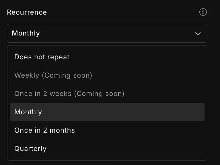
Available Recurrence Options
When placing a monitoring order, you can select from the following recurrence frequencies:
Weekly (Coming soon, after the launch of the rest 3 satellites in the constellation)
Once in 2 weeks (Coming soon)
Monthly
Bi-monthly
Quarterly
 Minimum Requirements for Monitoring Orders
To qualify as a monitoring order, your request must meet these criteria:
A minimum of 4 recurrences must be scheduled
The time range selected must be sufficient to accommodate all recurrences
Choosing the End Date
You can define the duration of your monitoring order in one of the following ways:
Select an end date up to two years from the start date
Choose a custom end date using the calendar (ensure it allows for at least 4 recurrences)
Specify the number of ocurrences, and the system will calculate the required duration automatically
Viewing Recurrence Details
Once your order is created, you can click on "View Recurring Orders" to see the planned time windows for each scheduled capture.
Tasking order delivery
See all articlesWhen will I receive my order?
The time it takes to receive your imagery depends on when your satellite capture is successfully completed and the delivery option selected for your order.
There are two separate stages:
- Capture: When Pixxel's satellite attempts to capture your Area of Interest (AOI).
- Delivery: How quickly the successfully captured imagery is processed and made available to you.
Order Timeline
Your tasking order follows this general lifecycle:
Order placed → Aurora Feasibility check → Capture window → Successful capture → Processing → Imagery delivered
1. Order Placement
Before placing a tasking order, Aurora checks whether your requested parameters are feasible.
The feasibility check considers factors such as:
- Area of Interest (AOI)
- Capture window
- Cloud-cover requirement
- Off-nadir requirement
- Satellite availability
- Other operational constraints
Only orders that pass the required checks can proceed to purchase.
2. Capture Window
Your capture window defines the period during which Pixxel may attempt to capture your imagery.
For Regular Tasking, the capture window must be at least 14 days.
The capture window does not represent a guaranteed capture date. Weather, satellite availability, scheduling constraints and other operational factors can affect when a successful capture occurs.
If a capture attempt is unsuccessful, additional attempts may be made within the available capture window, where applicable.
3. Successful Capture
Once your imagery has been successfully captured, the delivery timeline begins.
The delivery timeline is separate from the capture window.
For current delivery options:
| Delivery Option | Delivery Timeline |
|---|---|
| Standard | 14 days from successful capture |
| Express | 24 hours from successful capture* |
*Express delivery is currently coming soon and may not yet be available for all orders.
4. Imagery Delivery
Once processing is complete, your imagery is made available in your Aurora Catalog.
You can then access your imagery through Aurora and use the available download or cloud-delivery options.
How Can I Track My Order?
You can monitor your order from the Order Desk.
Order statuses provide information about where your order is in its lifecycle.
Common order statuses
| Status | What it means |
|---|---|
| Active | At least one task in the order has been submitted and is being processed through the tasking workflow. |
| Fulfilled | All tasks in the order have been successfully captured and delivered. |
| Partially Fulfilled | Some tasks have been successfully delivered, while others have not. |
| Failed | No imagery was successfully delivered for the order. |
| Cancelled | The order was cancelled, for example because payment or recharge was unsuccessful. |
For more detailed information about task and order statuses, see Order and Task Statuses.
Will My Image Definitely Be Captured?
No.
Passing the feasibility check means that Aurora has determined that your requested parameters are feasible based on the available information. It does not guarantee a successful capture.
Unexpected weather, satellite scheduling, cloud conditions or other operational factors may affect the outcome.
What If My Capture Is Unsuccessful?
If a capture attempt is unsuccessful, Pixxel may make additional capture attempts within the order's capture window, where applicable.
If the order reaches the end of its capture window without a successful capture, its final status will reflect the outcome of the order.
If you need help understanding the status of your order, contact support@pixxel.space.
Where Will I Receive My Imagery?
Once your imagery has been processed, it is available in your Aurora Catalog.
From there, you can access the imagery through Aurora or use the available delivery options to send it to a configured cloud storage location.
Important: Capture Time vs. Delivery Time
Remember that these are two different timelines:
Capture timeline:
How long it takes for Pixxel to successfully capture your requested imagery within your selected capture window.
Delivery timeline:
How long it takes to process and make the imagery available after a successful capture.
For example, if your capture window is 14 days and Pixxel successfully captures your imagery on Day 10, the delivery timeline starts on Day 10—not when you originally placed the order.
Difference between Orders and Tasks
A quick guide to understanding the structure of Pixxel orders.
Every order you place is broken into one or more tasks, depending on what you’re requesting. This structure helps the system track feasibility, scheduling, and delivery more accurately.
How it works
- Order = The overall request (tasking, archive, or recurring)
- Task = The actionable unit inside an order. Can include multiple captures based on the size of the AOI.
Examples:
- Single tasking order → 1 task
- Archive order → 1 task
- Recurring order → Multiple tasks, each representing one scheduled capture
Note: Future recurring tasks stay in Draft until their feasibility check and placement 5 days before the start date. But the Order stays in Active state from the time of placement of first instance. To understand task statuses, refer to this article.
Statuses Explained
Order statuses summarize the outcome of all tasks inside that order. They help you quickly understand whether your order is complete, partially successful, or still in progress.But within each order, there might be separate tasks as well and each task moves through its own lifecycle. This article explains the different statuses and their meanings.
| Task Status | Order Status |
|
|
DISCLAIMER:
- Orders which are Active indicates the order has passed feasibility/payment and is now in the scheduling queue all the way up to image delivery.
- Tasks which are In Progress would indicate that capture attempts have been made and the images are either being processed or need to be recaptured. Please reach out to support@pixxel.space to understand the exact status of your order.
You can find more detailed definition of status in the Aurora User Guide.
How to download ordered imagery from Aurora?
1. You can export the images to our preferred delivery process
2. You can choose your desired delivery method - Local and Cloud storage
3. Save your preferred selection for future orders.
Export File Formats on Aurora
Aurora currently delivers hyperspectral imagery as individual strips (segments of the full satellite capture). Clipping to custom areas or mosaicing multiple strips into a seamless scene will be available in a future release.
| File Name | Format | Description |
|---|---|---|
| Primary Image Files | GeoTIFF | The capture area at the specified processing level. |
| Quality Mask File | GeoTIFF | Mask identifying cloud, cloud shadow, water, and other quality flags at bit-encoded layers. |
| Footprint Polygon | GeoJSON | Exact acquisition footprint. |
| Bounding Box Polygon | GeoJSON | Rectangular bounding extent of the acquisition. |
| ENVI Header File | .hdr | Providing band, wavelength, and projection information for direct hyperspectral processing. |
| Thumbnail Preview | JPEG | Quicklook for rapid scene visualization. |
| ReadMe File | .txt | A text document describing package contents, filename conventions, quality mask bit definitions, and processing notes. |
Access Pixxel Imagery
See all articlesWhat is the minimum order size for tasking or archive?
Tasking:
The minimum order size for a tasking image is 100 sq km, which would cost $800.
Archive:
The minimum order size for an archive is currently the size of the captured image. We charge $8 per sq km.
How to Order Archive Imagery
1 min Video Tutorial -
This guide walks you through the process of ordering new satellite imagery through the Order Desk.
Getting Started
1. Navigate to the Explore page
2. Click on "Heatmap" in the dropdown menu
- Choose your preferred satellite options:
- Pixxel-TD01
- Pixxel-TD02
- Pixxel-Firefly or
- All
Finding Available Imagery
- Explore the world map to locate available imagery
- Look for red location markers indicating capture points
- Zoom out to view the global distribution of available imagery
1. Click on a marker to preview available images for that location
Hover over the image on the right to access
Click "Add to cart" for your desired image
- Fill out the order form:
- Name your order
- Select appropriate use case
- Assign to a project (if applicable)
- Confirm by clicking "Add to cart"
Checkout Process
- Access your cart via the cart icon in the left sidebar
- Review your selected imagery
- Click on Place order to place the order
Once your order is processed, your satellite imagery will be available in the catalogue
In case you have any further questions reach out to: support@pixxel.space
How to Access the Catalog in Aurora
All your purchased imagery is stored securely in your Catalog for immediate access whenever you need it, making it your centralized repository for all satellite data you own.
Accessing Your Catalog
- Open the Aurora platform through your web browser
- Locate the left sidebar menu that contains various navigation options
- Click on the "Catalog" icon - represented by an image gallery symbol in the sidebar (highlighted in yellow)
- Your catalog will immediately open, displaying all your purchased imagery
What's Available in Your Catalog
Your Catalog includes all imagery you've obtained through Aurora:
- Archive Imagery: Historical satellite images you've purchased
- Tasked Imagery: Custom satellite captures you've specifically ordered
Pricing
See all articlesTasking Products We Offer
Tasking allows you to request new satellite imagery of a specific Area of Interest (AOI) during a selected capture window.
Aurora currently supports Regular Tasking. You do not need to manually select a tasking product when placing an order. Simply select your desired capture window, and Aurora will apply the applicable tasking option automatically.
Regular Tasking
Regular Tasking is the standard option for requesting new imagery from Pixxel's satellites.
It is available when your selected capture window is 14 days or longer.
| Tasking Product | Capture Window | Price Uplift |
|---|---|---|
| Regular Tasking | 14 days or longer | No uplift |
How Regular Tasking works
When creating a tasking order:
- Define your Area of Interest (AOI).
- Select your capture window.
- Configure your preferred imaging parameters, such as:
- Cloud cover
- Off-nadir angle
- Spectral bandset
- Run the Feasibility Check to confirm that the requested parameters can be fulfilled.
- Add the order to your cart and proceed with checkout.
Important considerations
- The capture window must be at least 14 days.
- Your selected capture window must meet Aurora's tasking feasibility requirements.
- The capture window dates are interpreted in UTC.
- The start date of your capture window must be at least 48 hours after the order is placed.
- A feasibility check helps determine whether the requested capture is achievable, but it does not guarantee successful image capture. Weather, satellite availability, scheduling constraints, and other operational factors may affect the outcome.
Note: Tasking product availability and pricing may change as new tasking options are introduced to Aurora. Any additional tasking products will be reflected in Aurora when they become available.
Need a different capture timeline?
If your required capture window does not meet the Regular Tasking requirements, adjust your requested dates and run the feasibility check again.
For questions about tasking requirements or feasibility, contact support@pixxel.space.
Understanding Capture Timelines
When placing a tasking order in Aurora, you select the dates during which you want Pixxel's satellite to attempt to capture imagery of your Area of Interest (AOI).
Aurora currently supports Regular Tasking.
Regular Tasking
Regular Tasking is the standard option for requesting new satellite imagery.
| Tasking Product | Minimum Capture Window | Price Uplift |
|---|---|---|
| Regular Tasking | 14 days | No uplift |
A Regular Tasking order must have a capture window of at least 14 days.
You do not need to manually select a tasking product. Aurora determines the applicable tasking option based on the capture window you provide.
Capture Window
Your capture window is the period during which Pixxel's satellites may attempt to capture your requested imagery.
For example:
- Start date: 1 October
- End date: 15 October
- Capture window: 14 days
A longer capture window generally provides greater flexibility for scheduling a successful capture.
Capture Window Requirements
When creating a tasking order:
- Your capture window must be at least 14 days.
- Capture window dates are entered in UTC.
- Your selected start date must be at least 48 hours after the order is placed.
- Your order must pass Aurora's Feasibility Check before it can be placed.
Aurora checks factors such as your AOI, capture window, cloud-cover requirement, off-nadir requirement, and satellite availability to determine whether the requested capture is feasible.
Does a shorter capture window cost more?
At present, Aurora does not offer additional tasking-product tiers based on shorter capture windows.
Regular Tasking has no tasking-product price uplift.
If your requested dates do not meet the requirements for Regular Tasking, Aurora will indicate that the order cannot be fulfilled with the selected parameters. You can then adjust your capture window or other tasking parameters and run the feasibility check again.
What affects the likelihood of a successful capture?
A tasking order being marked as feasible does not guarantee that an image will be successfully captured.
Actual capture can be affected by factors such as:
- Weather and cloud conditions
- Satellite availability
- Scheduling constraints
- Off-nadir requirements
- The size and location of your AOI
- Other operational constraints
Aurora's Feasibility Check is designed to identify whether your requested parameters are practical before you place the order. However, unexpected conditions may still affect the final capture.
Cloud Cover and Off-Nadir Requirements
You can specify cloud-cover and off-nadir preferences when creating your tasking order.
More restrictive requirements can reduce the number of opportunities available for a successful capture. For example, selecting a tighter off-nadir range or a lower cloud-cover threshold may make an order more difficult to fulfil.
For more information, see:
- Off-Nadir and Cloud Cover
- Feasibility Check
- Tasking Products We Offer
Important
The capture window determines when Pixxel may attempt to capture your imagery. It should not be interpreted as a guaranteed capture date.
If you need help selecting an appropriate capture window or tasking configuration, please contact Pixxel Support.